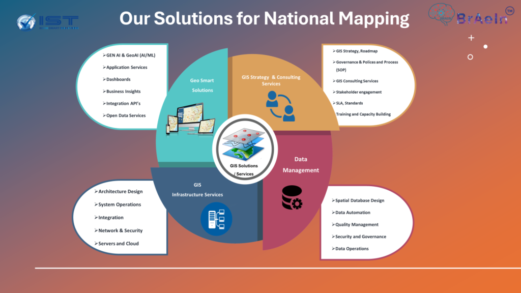
Collaboration Opportunities:
Collaboration between national mapping agencies and the private sector is crucial for fostering innovation in the rapidly evolving geospatial sector. This partnership can leverage diverse strengths, including setting standards, developing policies, and creating a robust legal framework. Such collaborations aim to enhance technology innovation solutions, software development, and people capacity building. They also promote knowledge sharing across the full value chain of geospatial technologies, touching every sector.
Challenges and Need for Collaboration:
Despite the immense potential of geospatial technologies, several challenges hinder their widespread adoption and effective use. One significant challenge is data source fragmentation, leading to inconsistencies and a lack of standardization. Additionally, there is a gap in the availability of skilled professionals who can integrate and analyze geospatial data using advanced tools like Geo Analytics and Mapping, GEO AI and Generative AI.
Moreover, ensuring the security and governance of sensitive geospatial data while promoting open data initiatives presents a complex challenge. Clear policies, standards, and control processes are critical to addressing data privacy concerns and ensuring that innovations benefit community development and make a difference.
There is also a growing demand for affordable access to high-quality geospatial data and technologies, especially for smaller organizations and developing regions. Addressing this requires collaboration to create cost-effective solutions to democratize access to these vital resources.
Transformative Technologies:
Key innovations, including Earth observation, Geo AI, and Generative AI, transform real-time data into actionable intelligence, enabling smarter decision-making. Companies like iSpatial Techno Solutions (IST) (IST) are at the forefront of this transformation, providing innovative spatial data infrastructure solutions. By applying the intelligence of GEO AI and GEO LLM Models, iSpatial Techno Solutions (IST) transforms raw data into meaningful insights, adding significant value to communities.
Key Advantages:
- Governance and Collaboration: There is a noticeable increase in governance and transparency, fostering trust and efficient collaboration between public and private entities. This maturity in geospatial thinking is becoming more prevalent in the community.
- Innovation and Open Data: Numerous open data sources and technologies are available, providing ample opportunity for research and development (R&D) and validating innovative concepts through developing minimum viable products (MVPs) to ensure we bring value to the community.
- Government Openness: Government sectors are increasingly open to collaborating with the private sector, co-innovating to impact communities significantly.
- Affordable Costs: The collaborative efforts in the geospatial sector have made geospatial data and technology more accessible and affordable, ensuring wider adoption and implementation
UNGGIM and Global Support:
The United Nations Global Geospatial Information Management (UN-GGIM) supports these efforts with frameworks like the Integrated Geospatial Information Framework (IGIF). The Private Sector Network (PSN) collaborates to implement these frameworks, contributing to local, national, and global sustainable development.
Academic and R&D Contributions:
The academic sector plays a vital role by supporting R&D and innovation in geospatial sciences. By applying the latest GIS and AI technologies, academic institutions, in partnership with the private sector, are pushing the boundaries of what's possible in geospatial intelligence.
Data Governance and Security:
While data governance, security, and sharing remain significant concerns, implementing proper policies, service level agreements (SLAs), standards, and control processes can enhance security. These measures ensure that innovations in the geospatial sector effectively address global and local challenges.
Summary:
In conclusion, innovation in the geospatial sector is pivotal in addressing many global and local challenges. By enhancing data quality, advancing technology, strengthening governance, and building capacity, we are poised to enable the next generation of geospatial innovations.
For the past 15 years, iSpatial Techno Solutions has been leading the charge, demonstrating the immense potential of location intelligence solutions, GEO AI and GEO LLM Models in transforming data into actionable intelligence to create differences in the community. This collaborative effort between national mapping agencies, the private sector, and academic institutions is a testament to the power of partnership in creating a better future for all.

Thank & Regards,
Vattem Narendra Babu
CEO- iSpatial Techno Solutions Inc.